|
1
|
- Predicting Soil Erosion By Water:
A Guide to Conservation Planning
|
|
2
|
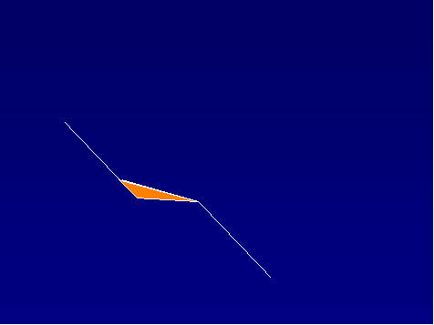
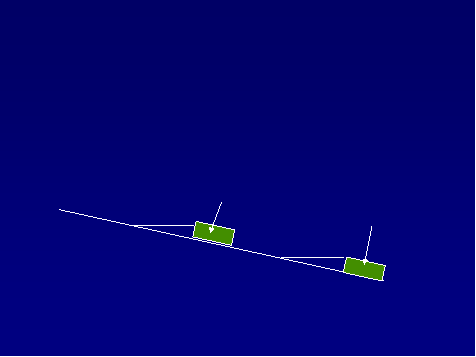
- Course Objectives and Topics
|
|
3
|
- Understand erosion processes
- Learn RUSLE2 and its software
- Learn field office applications of RUSLE2
|
|
4
|
|
|
5
|
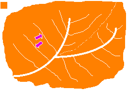
- Definition of erosion
- Erosion processes
- Types of erosion
- Why erosion is a concern
- Uses of erosion prediction tools
|
|
6
|
- “Erosion is a process of detachment and transport of soil particles by
erosive agents.”
- Erosive Agents
- Raindrop impact
- Overland flow surface runoff from rainfall
|
|
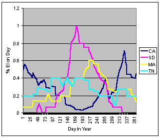
7
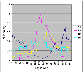
|
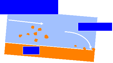
- Removal of soil particles from soil surface
- Adds to the sediment load
- Sediment load: Rate sediment is transported downslope by runoff
|
|
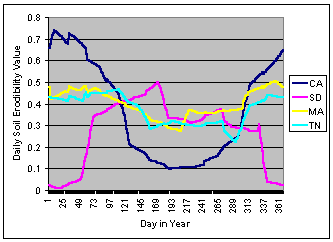
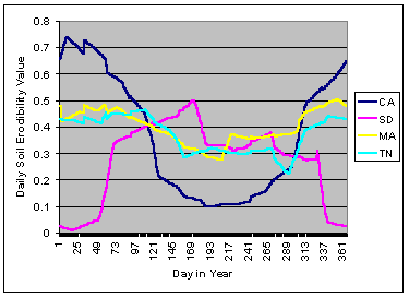
8
|
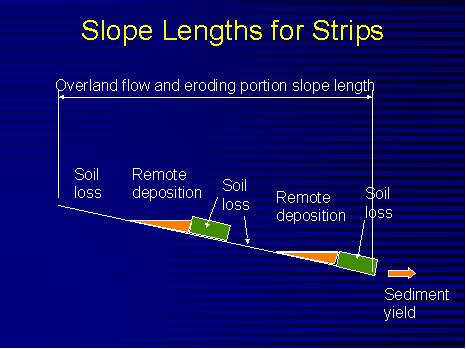
|
|
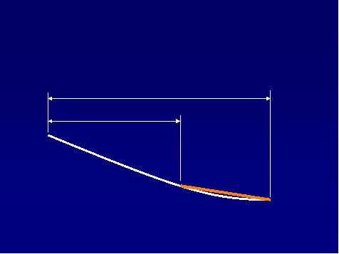
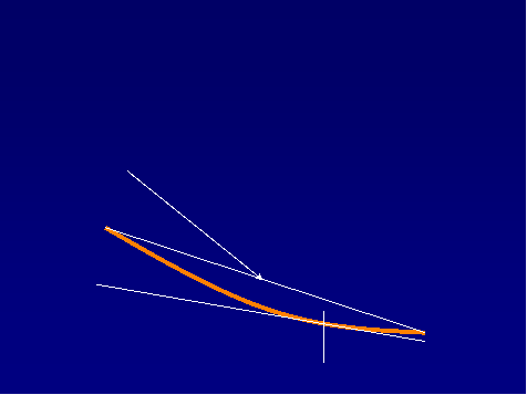
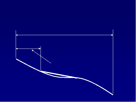
9
|
- Reduces the sediment load
- Adds to the soil mass
- Local deposition
- Surface roughness depressions
- Row middles
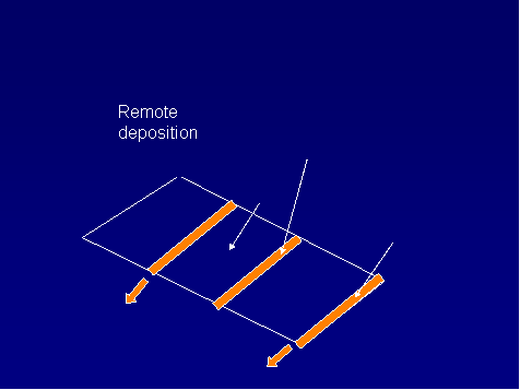
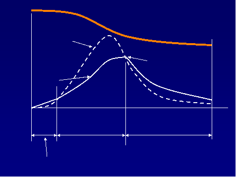
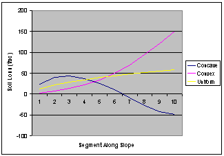
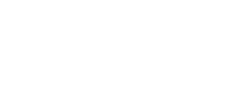
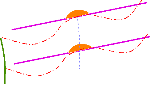
- Remote deposition
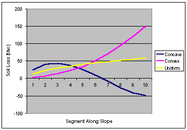
- Concave slope
- Strips
- Terraces
|
|
10
|
|
|
11
|
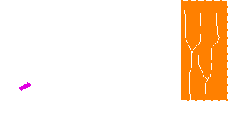
- Interrill and rill (sheet-rill)
- Ephemeral gully
- Permanent, incised (classical) gully
- Stream channel
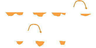
- Mass movement
- Geologic
|
|
12
|
|
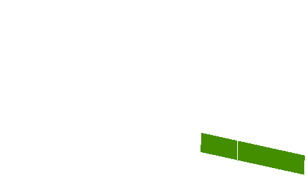
|
13
|
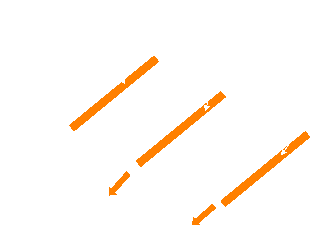
|
|
14
|
|
|
15
|
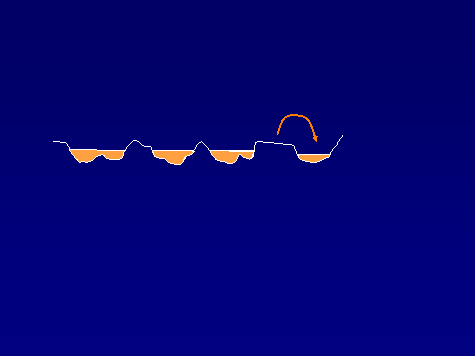
|
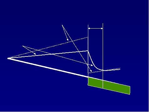
|
16
|
|
|
17
|
|
|
18
|
- Local Deposition
- Full credit
- Remote Deposition
- Partial credit
- Amount
- Location
- Spacing of terraces
|
|
19
|
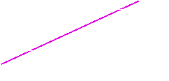
- Particle Classes
- Primary clay, primary silt, small aggregate, large aggregate, primary
sand
- At Detachment
- Distribution of classes function of texture
- Diameter of small and large aggregates function of texture
- After Deposition
- Sediment enriched in fines
|
|
20
|
- Degrades soil resource
- Reduces soil productivity
- Reduces soil organic matter
- Removes plant nutrients
- Causes downstream sedimentation
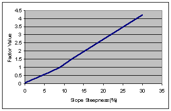
- Produces sediment which is a pollutant
- Produces sediment that carries pollutants
|
|
21
|
- Low residue crops
- Conventional tillage
- Rows up/down steep slopes
- Low maintenance pasture
- Disturbed land with little cover
|
|
22
|
- Guide management decisions
- Evaluate impact of erosion
- Inventory soil erosion
- Conservation planning
|
|
23
|
- Concept:
- Estimate erosion rate
- Evaluate by ranking
- Evaluate against quality criteria
- Tool: RUSLE2
- Quality Criteria: Soil loss tolerance
|
|
24
|
- Soil loss on eroding portions of hillslope
- Detachment (sediment production) on hillslope
- Conservation planning soil loss for hillslope
- Ratio of segment soil loss to soil tolerance adjusted for segment
position
- Sediment yield from hillslope/terraces
|
|
25
|
|
|
26
|
- Where RUSLE2 applies
- Major factors affecting erosion
- RUSLE2 factors
- RUSLE2 background
|
|
27
|
|
|
28
|
- Climate
- Soil
- Topography
- Land use
- Cultural practices
- Supporting practices
|
|
29
|
- r - Rainfall/Runoff
- k - Soil erodibility
- l - Slope length
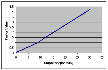
- s - Slope steepness
- c - Cover-management
- p - Supporting practices
|
|
30
|
- Climate r
- Soil k
- Topography ls
- Land Use and lscp
- Management
|
|
31
|
- A = f (erodibility, erosivity)
- Erosivity – rklscp
- Erodibility - klc
|
|
32
|
- Unit Plot Concept
- a = rk lscp
- rk - Unit plot soil loss
- (dimensions)
- lscp - Adjusts unit plot soil loss
- (dimensionless)
|
|
33
|
|
|
34
|
|
|
35
|
|
|
36
|
- Combines empirical field data-process based equations
- (natural runoff and rainfall simulator plots)
- Zingg’s equation (1940)
- Smith and Whit’s equation (1947)
- AH-282 (1965)
- “Undisturbed land” (1975)
- AH-537 (1978)
- Disturbed forestland (1980)
- RUSLE1 (1992)
- AH703 (1997)
- OSM Manual (mined, reclaimed land, construction sites) (1998)
- RUSLE2 (2001)
|
|
37
|
- Cropland
- Pastureland
- Rangeland
- Disturbed forest land
- Construction sites
- Surface mine reclamation
- Military training lands
- Parks
- Waste disposal/landfills
|
|
38
|
- Factors affecting erosion
- RUSLE2 factors
- RUSLE2 background
|
|
39
|
|
|
40
|
- r- erosivity factor
- k- erodibility factor
- l- slope length factor
- s- slope steepness factor
- c- cover-management factor
- p- supporting practices factor
|
|
41
|
- Single storm
- Energy x 30 minute intensity
- Fundamentally product of rainfall amount x intensity
- Annual-sum of daily values
- Average annual-average of annual values
- Daily value=average annual x fraction that occurs on a given day
|
|
42
|
- Las Vegas, NV 8
- Phoenix, AZ 22
- Denver, CO 40
- Syracuse, NY 80
- Minneapolis, MN 110
- Chicago, IL 140
- Richmond, VA 200
- St. Louis, MO 210
- Dallas, TX 275
- Birmingham, AL 350
- Charleston, SC 400
- New Orleans, LA 700
|
|
43
|
|
|
44
|
- Reflects locations where intense, erosive storms occur that have a
greater than proportional share of their effect on erosion
- Effectiveness and failure of contouring
- Effect of ponding on erosivity
- Sediment transport capacity
|
|
45
|
- Significant water depth reduces erosivity of raindrop impact
- Function of:
|
|
46
|
- Measure of soil erodibility under standard unit plot condition
- 72.6 ft long, 9% steep, tilled continuous fallow, up and down hill
tillage
- Independent of management
- Major factors
- Texture, organic matter, structure, permeability
|
|
47
|
- Effect of texture
- clay (0.1 - 0.2) resistant to detachment
- sand (0.05 - 0.15) easily detached, low runoff, large, dense particles
not easily transported
- silt loam (0.25 - 0.35) moderately detachable, moderate to high runoff
- silt (0.4 -0.6) easily detached, high runoff, small, easily transported
sediment
|
|
48
|
- Varies during year
- High when rainfall is high
- Low when temperature is high
- Very low below about 25 °F
|
|
49
|
|
|
50
|
- Overland flow slope length
- Slope lengths for eroding portions of hillslopes
- Steepness
- Hillslope shape
|
|
51
|
|
|
52
|
- Distance from the origin of overland flow to a concentrated flow area
- This slope length used when the analysis requires that the entire slope
length be considered.
|
|
53
|
- Only works for simple slopes
- Traditional definition
- Distance from origin of overland flow to concentrated flow or to where
deposition begins
- Definition is flawed for strips and concave:convex slopes
- Best approach: Use overland flow slope length and examine RUSLE2 slope
segment soil loss values
|
|
54
|
|
|
55
|
|
|
56
|
|
|
57
|
|
|
58
|
|
|
59
|
- Sediment load accumulates along the slope because of detachment
- Transport capacity function of distance along slope (runoff), steepness
at slope location, cover-management, storm severity (10 yr EI)
- Deposition occurs where sediment load becomes greater than transport
capacity
|
|
60
|
- Slope length effect
- l= (x/72.6)n
- x = location on slope
- n = slope length exponent
- Slope length exponent
- Related to rill:interrill ratio
- Slope steepness, rill:interrill erodibility, ground cover, soil
biomass, soil consolidation
- Slope length factor varies on a daily basis
|
|
61
|
- Slope length effect is greater on slopes where rill erosion is greater
relative to interrill erosion
- Examples:
- Steep slopes
- Soils susceptible to rill erosion
- Soils recently tilled
- Low soil biomass
|
|
62
|
|
|
63
|
|
|
64
|
- Cover-management
- Supporting practices
|
|
65
|
- Vegetative community
- Crop
- Crop rotation
- Conservation tillage
- Application of surface and buried materials (mulch, manure)
- Increasing random roughness
|
|
66
|
- Contouring
- Strip systems
- Buffer, filter, strip cropping, barriers
- Terrace/Diversion
- Impoundments
- Tile drainage
|
|
67
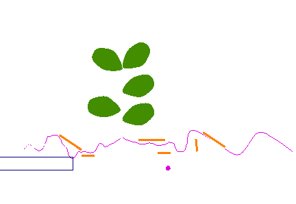
|
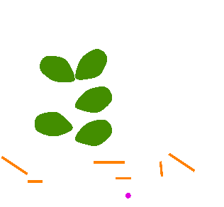
- Canopy
- Ground cover
- Surface Roughness
- Ridges
- Below ground biomass
- Live roots, dead roots, buried residue
- Soil consolidation
- Antecedent soil moisture (NWRR only)
|
|
68
|
|
|
69
|
- Cover above soil surface that intercepts rainfall but does not touch
soil surface to affect surface flow
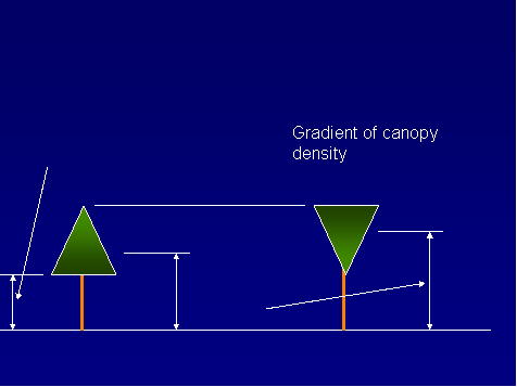
- Main variables
- Percent of surface covered by canopy
- Effective fall height
|
|
70
|
|
|
71
|
- Cover directly in contact with soil surface that intercepts raindrops,
slows runoff, increases infiltration
- Examples
- Live plant material
- Plant residue and litter
- Applied mulch
- Stones
|
|
72
|
|
|
73
|
- Live cover depends on type of vegetation, production level, and stage
- Residue
- Amount added by senescence, flattening, and falling by decomposition at
base
- Decomposition
- Rainfall amount
- Temperature
|
|
74
|
- Canopy over ground cover is considered to be non-effective
- As fall height approaches zero, canopy behaves like ground cover
|
|
75
|
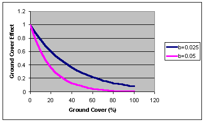
- Creates depressions
- Usually creates erosion resistant clods
- Increases infiltration
- Increases hydraulic roughness that slows runoff, reducing detachment and
transport capacity
|
|
76
|
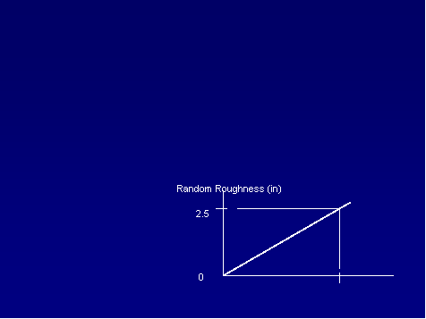
- Standard deviation of micro-elevations
- Roughness at tillage function of:
- Implement
- Roughness at time of disturbance and tillage intensity
- Soil texture
- Soil biomass
- Decays with:
- Rainfall amount
- Interrill erosion
|
|
77
|
- Ridges up and downhill increase soil loss by increasing interrill
erosion
- Function of:
- Effect increases with ridge height
- Effect decreases with slope steepness above 6%
- Ridge height decays with rainfall amount and interrill erosion
- Effect shifts from increasing soil loss when up and downhill to
decreasing soil loss when on the contour
|
|
78
|
- Killing vegetation converts live standing to dead standing and live
roots to dead roots
- Operations
- Flatten standing residue to flat residue (ground cover)
- Bury flat residue
- Resurface buried residue
- Redistribute dead roots in soil
- Material spread on surface
- Material incorporated (lower one half of depth of disturbance)
- Decomposition at base causes standing residue to fall
|
|
79
|
- Function of:
- Rainfall
- Temperature
- Type of material
- Standing residue decays much more slowly
|
|
80
|
- Live roots
- Distributed non-uniformly within soil
- Dead roots
- Buried residue
- Half of material decomposed on surface is added to upper 2 inches
- Incorporated biomass
|
|
81
|
- Roots mechanically hold the soil
- Add organic matter that improves soil quality, reduces erodibility,
increases infiltration
- Affect rill erosion more than interrill erosion
- Effect of roots considered over upper 10 inches
- Effect of buried residue over upper 3 inches, but depth decreases to 1
inch as soil consolidates (e.g. no-till)
|
|
82
|
- Overall, freshly tilled soil is about twice as erodible as a fully
consolidated soil
- Erodibility decreases with time
- Seven years in the Eastern US
- Depends on rainfall in Western US, up to 25 years
|
|
83
|
- Width of disturbance taken into account in surface cover, random
roughness, and soil consolidation
|
|
84
|
- Soil loss depends on how much moisture previous cropping systems have
removed from soil
|
|
85
|
- Contouring/Cross-slope farming
- Strips/barriers
- Rotational strip cropping, buffer strips, filter strips, grass hedges,
filter fence, straw bales, gravel bags
- Terraces/diversions
- Impoundments
|
|
86
|
- Redirects runoff
- Fail at long slope lengths
- Effectiveness depends on ridge height
- (no ridge height—no contouring effect)
|
|
87
|
- Function of:
- Ridge height
- Row grade
- Cover-management
- Hydrologic soil group
- Storm severity (10 yr EI)
- Varies with time
- Tillage that form ridges
- Decay of ridges
|
|
88
|
- If slope length longer than critical slope length, contouring fails
allowing excessive rill erosion
- Function of:
- Storm severity, slope steepness, cover-management, EI distribution
- Critical slope length extensions below strips depend on degree that
strip spreads runoff
- Terraces are used if changing cover-management or strips are not
sufficient
- Soil disturbance required to restore failed contouring
|
|
89
|
- Narrow strips of dense vegetation (usually permanent grass) on contour
- Effective by inducing deposition (partial credit) and spreading runoff
- Most of deposition is in backwater above strip
- Buffer strips
- Multiple strips
- Either at bottom or not a strip at bottom
- Water quality-must have strip at bottom and this strip twice as wide as
others
- Filter strip-single strip at bottom
|
|
90
|
- Equal width strips on contour
- Strips are rotated through a crop rotation cycle
- Offset starting dates among strips so that strips of close growing
vegetation separate erodible strips
- Benefit:
- Deposition (full credit)
- Spreading runoff
- Reduced ephemeral gully erosion not credited in RUSLE2
|
|
91
|
- Ridges and channels periodically placed along hillslope that divides
hillslope into shorter slope lengths except for widely spaced parallel
terraces that may have not effect on slope length
- Benefit:
- Shorten slope length and trap sediment
- Runoff management system
- Evenly spaced
- May or may have a terrace at bottom
- Maintenance required to deal with deposition
|
|
92
|
|
|
93
|
- Deposition occurs when sediment load is greater than transport capacity
- Sediment load from sediment entering from overland area
- Transport capacity function of grade and storm erosivity
- Deposition depends on sediment characteristics
- Deposition enriches sediment in fines
|
|
94
|
- Ridges and channels placed at strategic locations on hillslope to
shorten slope length
- Reduce runoff rate and rill erosion
- Generally designed with a steepness sufficiently steep that no
deposition occurs but not so steep that erosion occurs
|
|
95
|
- Deposition by settling process
- Function of:
- Sediment characteristic of sediment load reaching impoundment
|
|
96
|
- Hydraulic elements-channels and impoundments
- Can create a system
- Can put channels-impoundments in sequence
- Examples:
- Tile outlet terrace—channel:impoundment
- Impoundments in series—impoundment:impoundment
|
|
97
|
- Depends on type of deposition
- Local deposition gets full credit
- Remote deposition gets partial credit
- Credit for remote deposition
- Depends on location on hillslope
- Deposition at end gets almost no credit
|
|
98
|
- Reflects effects of deep drainage systems
- Tile drainage systems
- Lateral, deep drainage ditches
- Describe by:
- Assigning hydrologic soil group for undrained and drained soil
- Fraction of area drained
|
|
99
|
- Worksheets
- Profiles
- Climate
- EI distribution
- Soil
- Management
- Operations
- Vegetation
- Residue
- Contouring
- Strips
- Diversion/terrace, sediment basin systems
- Sequence of hydraulic elements
|
|
100
|
- Central part of a RUSLE2 soil loss estimate
- Profile is reference to a hillslope profile
- Six things describe a profile
- Location, soil, topography, management, supporting practice, hydraulic
element system
- Topography described with profile
- Can specify segments by length and steepness for topography, segments
by length for soil, segments by length for management
- Name and save with a name
|
|
101
|
- Three parts: Alternative managements, practices; Alternative profiles;
Profiles for a field or watershed
- Alternative management, practices
- Compare alternatives for a single hillslope profile
- Alternative profiles
- Compare specific hillslope profiles
- Field/Watershed
- Compute average soil loss/sediment yield for a field or watershed
- Name and save worksheets
|
|
102
|
- RUSLE2 has been calibrated to experimental erosion data using assumed
data values for such things as cover-mass, residue at harvest,
decomposition coefficient, root biomass, burial ratios, etc.
- The data used in this calibration are core calibration values
- Data used in RUSLE2 applications must be consistent with these values
- Core databases were set up for vegetation, residue, and operations
- NRCS data manager maintains these databases
- Working databases developed from the core databases
|
|
103
|
- RUSLE2 DEFINITIONS, RULES, PROCEDURES, and CORE DATA MUST BE FOLLOWED
FOR GOOD RESULTS.
- Can’t independently change one set of data without recalibrating.
- Must let RUSLE2 factors and subfactors represent what they were intended
to represent.
- For example, the K factor values are not to be modified to represent
the effect of organic farming.
The cover-management subfactors represent the effects of organic
farming.
- Don’t like these rules—then don’t use RUSLE2 because results won’t be
good.
|
|
104
|
- Input values for values used to described weather at a location, county,
management zone
- Principal values
- Erosivity value, 10 yr EI value, EI distribution, monthly rainfall,
monthly temperature
- Designate as Req zone and corresponding values
- Data available from NRCS National Weather and Climate Center
- Name and save by location
|
|
105
|
- 24 values that describe distribution of erosivity R throughout year
- For a location, county, management zone, EI distribution zone
- Data available from NRCS Weather and Climate Center
- Name and save
|
|
106
|
- Data describes base soil conditions for unit plot conditions
- Data include erodibility value, soil texture, hydrologic soil group of
undrained soil, efficient subsurface drainage, time to full soil
consolidation, rock cover
- Erodibility nomograph available to estimate soil erodibility factor K
- Data available from NRCS soil survey database
- Name and same
|
|
107
|
- Array of dates, operations, vegetations
- Specify if list of operations is a rotation
- Rotation is a cycle when operations begin to repeat
- Rotations used in cropping
- Rotations often not used immediately after land disturbances like
construction and logging during recovery period
- Length of rotation
- Yield, depth, speeds of operations
- Added materials and amounts
- NRCS databases, Extension Service
- Name and save
|
|
108
|
- Operations describe events that change soil, vegetation, and residue
conditions
- Mechanical soil disturbance, tillage, planting, seeding, frost, burning,
harvest
- Describe using effects and the sequence of effects
- Speed and depth
- Source of data: Research core database, NRCS core database, working
databases
- Name and save
|
|
109
|
- No effect
- Begin growth
- Kill vegetation
- Flatten standing residue
- Disturb surface
- Live biomass removed
- Remove residue/other cover
- Add other cover
|
|
110
|
- No effect
- Primarily used to obtain output at particular times or to add fallow
years when not operation occurs in that year
- Begin growth
- Tells RUSLE2 to begin using data for particular vegetation starting at
day zero
- Typically associated with planting and seeding operations
- Kill vegetation
- Transfers mass of above ground live vegetation into standing residue
pool
- Transfers mass live roots into dead root pool
- Typically used in harvest and plant killing operations
|
|
111
|
- Flatten standing residue
- Transfer residue mass from standing pool to flat, ground surface pool
- Based on a flattening ratio that is a function of residue type
- Used in harvest operations to determine fraction of residue left
standing after harvest
- Used in tillage and other operations involving traffic to determine
fraction of residue left standing after operation
|
|
112
|
- Disturb surface
- For mechanical soil disturbance that loosens soil
- Tillage type (inversion, mixing+some inversion, mixing only, lifting
fracturing, compression) determines where residue is placed in soil and
how residue and roots are redistributed within soil
- Buries and resurfaces residue based on ratios that depend on residue
type
- Tillage intensity (degree that existing roughness is obliterated)
- Recommended, minimum, maximum depths
- Initial ridge height
- Initial, final roughness (for the base condition)
- Fraction surface area disturbed (tilled strips)
|
|
113
|
- Live biomass removed
- Fraction removed
- Fraction of that removed that is “lost” and left as ground cover (flat
residue)
- Used with hay and silage harvest operations
- Remove residue/other cover
- All surface residues affected or only most recent one?
- Fraction of standing cover removed
- Fraction of flat cover removed
- Used in baling straw, burning operations
|
|
114
|
- Add other cover
- Fraction added to surface versus fraction placed in soil
- Unless all mass added to surface, must be accompanied by disturbed soil
effect (that is, mass can not be placed in soil without disturbance)
- Mass placed in soil is placed between ½ and maximum depth
- Used to add mulch and manure to surface, inject manure into soil
|
|
115
|
- Live plant material
- Static variables include:
- Residue name, yield, retardance, senescence, moisture depletion for
NWRR
- Time varying variables
- Root biomass in upper 4 inches
- Canopy cover percent
- Fall height
- Live ground (surface) cover cover percent
- Source of data: Research core database, NRCS core database, working
databases
- Name and save
|
|
116
|
- Residue at max canopy function of yield
|
|
117
|
- Residence function of yield, on contour, and up and down hill
|
|
118
|
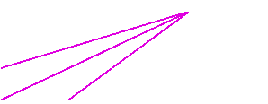
- RUSLE2 chooses retardance based on row spacing and the retardance
selected for a strip of the vegetation on the contour
- How does vegetation slow the runoff?
- Row spacing
- Vegetation on ridge-no retardance effect
- Wide row-no retardance effect (> 30 inches spacing)
- No rows, broadcast-same as strip on contour
- Narrow row-small grain in about 7 inch spacing
- Very narrow-same as narrow row except leaves lay in row middle to slow
runoff
- Moderate-about 15 to 20 inches spacing
|
|
119
|
- Size, toughness
- 5 types: small, fragile (soybeans); moderate size, moderately fragile
(wheat); large size, nonfragile (corn); large size, tough (woody
debris); gravel, small stones
- Decomposition (coefficient, halflife)
- Mass-cover values
- Source: NRCS databases
- Name and save
|
|
120
|
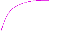
- Input the fraction of the biomass at max canopy that falls to soil
surface when canopy decreases from its max value to its min value.
- Input the minimum canopy value that corresponds to fraction that
experiences senescence
- Mass that falls is computed from difference in canopy percentages and
nonlinear relationship between canopy percent and canopy mass
|
|
121
|
- To have contouring, must have ridge heights
- To have ridge height, must have operation
- Ridge height assigned in operation
- Row grade
- Relative row grade (preferred) or absolute
- Create contouring practices based on relative row grade (row grade/land
slope)
- Perfect (0%), exceeds NRCS specs (5%), meets specs (10%), Cross slope (25%), Cross slope (50%)
- Name and save contouring practice
|
|
122
|
- Types
- Filter, buffer, rotational strip cropping
- Filter
- Specify width and management on strip
- Buffer
- Specify number, whether strip at bottom, for erosion or water quality
control, width, strip management
- Rotational strip cropping
- Specify number, timing of rotation on each strip
- Name and save
|
|
123
|
- Channels
- Impoundments
- Specific order of elements
- Name and save sequence
|
|
124
|
- System composed of named sequence of hydraulic elements
- Number of systems on hillslope
- Is the last one at the bottom of the slope?
- Name and save systems
|
|
125
|
- Represented by:
- Hydrologic soil group for soil when it is well drained
- Fraction of area that is drained
- Name and save
|
|
126
|
|
|
127
|
- How well does RUSLE apply to this situation?
- Erosion Processes
- Land Uses
- Geographic Regions
- Temporal Scale
- Uncertainty in computed values
|
|
128
|
- Yes: Interrill and rill erosion
- Yes: Sediment yield from overland
flow slope length
- Yes: Sediment yield from terrace channels and simple sediment control
basins
- No: Ephemeral or permanent
incised gully erosion
- No: Stream channel erosion
- No: Mass wasting
|
|
129
|
- All land uses where overland flow and interrill-rill erosion occurs
- Land use independent
- Best: Cropland
- Moderate: Disturbed lands like military lands, construction sites,
landfills, reclaimed lands
- Acceptable: Rangelands, disturbed forestlands, parks and recreational
areas
|
|
130
|
- Best: Clean tilled corn, soybean,
wheat crops
- Moderate: Conservation tillage, rotations involving hay
- Acceptable: Hay, pasture
- Most variable: Support practices, especially contouring
|
|
131
|
- Rainfall occurs regularly
- Rainfall predominant precipitation
- Rainfall exceeds 20 inches
- Northwest Wheat and Range Region (NWRR) special case
- West problem area because of infrequent storms
|
|
132
|
- Best: Medium Texture
- Moderate: Fine Texture
- Acceptable: Coarse Texture
- NO: Organic
|
|
133
|
- Slope Length
- Best: 50 - 300 feet
- Moderate: 0 - 50 ft , 300 - 600 ft.
- Acceptable: 600 - 1000 feet
- NO: >1000 feet
|
|
134
|
- Slope Steepness
- Best: 3 - 20%
- Moderate: 0 - 3%, 20 - 35%
- Acceptable: 35 - 100%
- NO: >100%
|
|
135
|
- Best (±25%): 4 < A <
30 t/ac/yr
- Moderate (±50%): 1 < A <
4
- 30 < A < 50
- Least (>±100%):
A < 1
- (>±50%): A > 50
|
|
136
|
- Rule of thumb:
- A change in a RUSLE2 soil loss estimate by more than 10% is considered
significant and meaningful in terms of representing main effect.
- An change less than 10% is not considered significant in general
- The accuracy for RUSLE2 representing how main effects affect soil loss
is much better than the absolute accuracy for RUSLE2 estimating soil
loss at any particular location and landscape condition.
|
|
137
|
- Best: Average annual, average
annual season, average annual single day
- Least: Single storm provided
great care used, generally not recommended
|
|
138
|
- Change in soil loss per unit change in a particular variable
- Select a base condition
- Vary input values for a variables about base condition
- Sensitivity varies according to condition
- Variables with greatest sensitivity require greatest attention
|
|
139
|
- Some variables have a linear effect
- Erosivity factor R
- Slope steepness
- Effect of most variables is nonlinear
- Ground cover
- Below ground biomass
- Roughness
|
|
140
|
- Low sensitivity
- Slope length at flat slopes (0.5%) A= 4.6 t/a at k = 150 ft, 5.2 t/a at k = 500 ft, 5.5 t/a at k = 1000 ft
- Moderate sensitivity
- Slope length at steep slopes (20%) A = 129 t/a at k = 50 ft, A = 202 t/a at k = 100 ft, A = 317 t/a at k = 200 ft.
|
|
141
|
- High sensitivity-Ground cover single most important
- Most variables interrelated
- Ground cover at planting not as much as expected
- Sequence of operations
- Effect of depth for a tandem disk
- Depends on whether proceeded by moldboard plow
|
|
142
|
- RUSLE varies in its applicability
- Results from RUSLE must be judged
- Degree of confidence in results varies
|

 Notes
Notes